Whether you’re concerned about the lack of control over your data, invasive advertising, or digital surveillance, there are many reasons to shake off big tech services. This is a series of tutorials to help you get Google out of your private life and make it easier for your friends and family to do so as well. There are free and paid, open source, and private alternatives for almost every digital service. You may need to put in a bit of effort, but we promise you: you, your loved ones, and our society will be better off.
Your location data should be private!
Every time you open Google Maps or Apple Maps, the apps track your location and build a profile of your habits.
Google Maps records your precise location data continuously, saves your search history and the places you visit and uses this data to target you with location-based advertising. Google also shares aggregated data with third parties and creates a “Location Timeline” of everywhere you’ve been.
Apple Maps, while claiming to be more privacy-focused, still collects location data and search queries, though they state this data is processed on-device when possible and not linked to your Apple ID.
Navigation is a necessary feature in our modern lives and the good news is that there are privacy-respecting alternatives that provide excellent navigation capabilities without invasive tracking. Let’s explore some of these alternatives.
Privacy-respecting map apps
OpenStreetMap.org
OpenStreetMap (OSM) is a collaborative project creating a free, editable map of the world. Unlike proprietary alternatives, OSM is built and maintained by a community of volunteers and contains no tracking or advertising. It is open source and provides the map data that powers most privacy-focused navigation apps
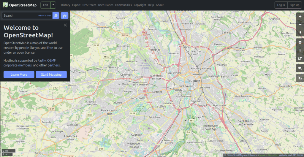
How to use OpenStreetMap:
- Visit openstreetmap.org in your browser
- Search for locations using the search bar
- Right-click anywhere and select “Directions from here” or “Directions to here” for basic navigation
- For a better experience on mobile, use one of the OSM-based apps we’ll cover next
While the web version offers basic functionality, OpenStreetMap also serves as the data source for the other navigation apps that add features like directions and offline maps.
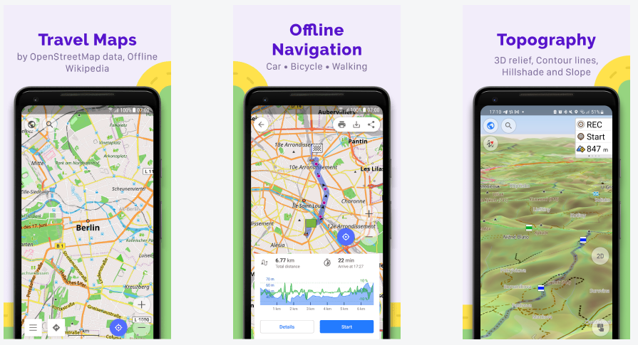
OsmAnd
OsmAnd (OpenStreetMap Automated Navigation Directions) is one of the most powerful privacy-focused navigation apps available. It works entirely offline, with no tracking, and offers advanced features that even surpass Google Maps in some areas.
Key features:
- Regularly updated maps
- Offline use with downloadable maps
- Voice navigation for driving
- Pedestrian, cycling, and public transport modes
- Topographic information, trip recording and planning
Installing OsmAnd:
For Android:
- Download the free version from F-Droid (most private option)
- Or get it preferably from the Aurora Store or Google Play Store if you have to (the free version allows up to 7 map downloads)
- For unlimited maps and all features, consider OsmAnd+ (paid version)
For iOS:
- Download OsmAnd from the App Store
- The iOS version offers in-app purchases for additional features
Getting started with OsmAnd:
- After installing, open the app and download maps for your region
- For each region, you can choose between standard maps, contour lines, Wikipedia POIs (Points of interest), and more
- Go to Settings to customize voice guidance, display options, and navigation settings
- Tap the map and then the directions icon to plan a route
- Long press anywhere to mark points or create waypoints for complex journeys
OsmAnd has a learning curve due to its numerous features, but the privacy benefits are worth the effort. The more you use it, the more you’ll discover how powerful this tool really is.
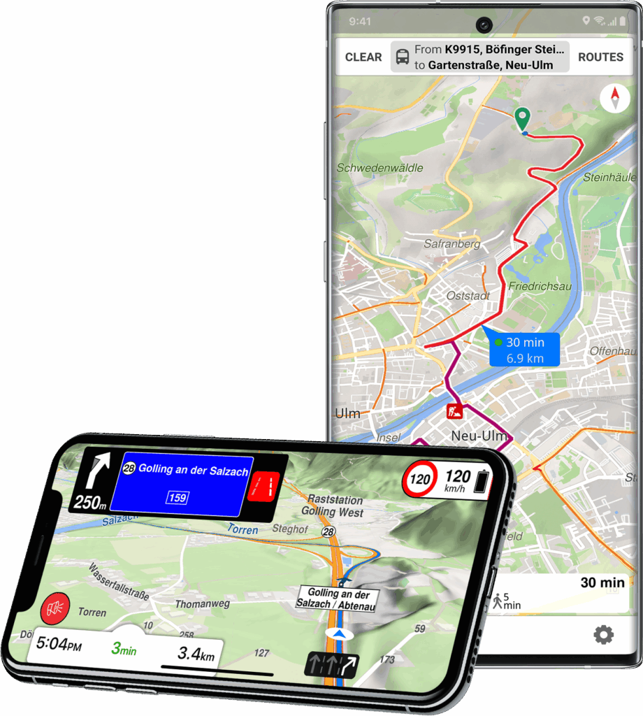
Magic Earth
If you’re looking for a more user-friendly alternative with a sleek interface, Magic Earth offers just that.
Free, with no ads or tracking, it offers:
- Car, pedestrian, bike, and public transport modes
- Elegant 3D maps available offline
- Voice guidance
- Real-time traffic info (anonymous)
- Lane assistance
- Built-in dashcam
Installing Magic Earth:
For Android:
- Download from Aurora Store if you prefer avoiding Google Play Store
For iOS:
- Download from the App Store
Getting started with Magic Earth:
- After installing, the app will ask permission to access your location (only while using the app)
- Download maps for your region by tapping the menu icon → “Offline Maps”
- Enter a destination in the search bar and tap “Directions”
- Choose your transportation mode (car, walking, cycling, public transit)
- Tap “Start Navigation” to begin turn-by-turn guidance
Magic Earth stands out for its simplicity and user-friendly design. If you’re used to the User Interface of Google or Apple Maps, Magic Earth might be a great choice for you. Their privacy policy is clear: “We don’t track you. We don’t share your data with anyone. Period.”, though, as of today, their source code has not been made public.
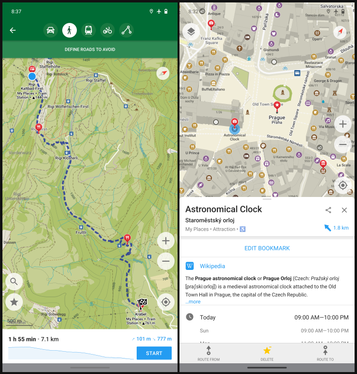
Organic Maps
Organic Maps is a newer app that has quickly gained popularity. It’s a fork of Maps.me (before that service began tracking users) with all proprietary and tracking elements removed.
Features:
- Import/export favorites in KML format
- 100% free and open source
- Works completely offline
- No ads, no tracking, no data collection
- Simple and clean interface
- Hiking trails, cycling routes, contour lines
Installing Organic Maps:
For Android:
- Download from F-Droid (most private option)
- Or get it from Aurora Store if you prefer avoiding Google Play Store
For iOS:
- Download from the App Store
Getting started with Organic Maps:
- After installing, download maps for your region
- Search for a destination using the search bar
- Tap the directions button to get routing options
- Choose between driving, walking, cycling, or public transit
- Tap “Start” to begin navigation
Organic Maps is perfect for users who want maximum privacy with minimum fuss. Its lightweight design also makes it ideal for older phones or devices with limited storage.
CoMaps – a community-run Organic Maps
This list wouldn’t be complete without mentioning the recent fork of Organic Maps, called CoMaps, which fosters community involvement. Only time will tell if the feature set of CoMaps differs from Organic Maps.
Comparing the Alternatives
| App | Best For | Special Features |
|---|---|---|
| OpenStreetMap.org | Quick web lookups | Community-edited maps |
| OsmAnd | Advanced users, outdoor enthusiasts | Extensive customization, detailed topography |
| Magic Earth | Everyday drivers wanting a polished experience | 3D view, dashcam, traffic info |
| Organic Maps | Minimalists, users with older devices | Lightweight, extremely simple |
| CoMaps | Minimalists, users with older devices | Lightweight, extremely simple |
Tips for Transitioning from Google or Apple Maps
- Download maps ahead of time: Unlike Google Maps which streams data constantly, privacy-focused alternatives work best with pre-downloaded maps. Make sure to download areas you’ll need before traveling.
- Give yourself time to adjust: The interfaces may be different from what you’re used to. Allow yourself a learning period before relying on them for critical navigation.
- Use multiple apps: Each privacy-focused map app has different strengths. You might prefer OsmAnd for hiking, Magic Earth for driving, and OpenStreetMap.org for quick lookups.
- Contribute to OpenStreetMap: If you notice missing information or outdated data, consider becoming a contributor to OpenStreetMap. This helps improve the maps for everyone.
- Stay patient with POI data: Points of interest (restaurants, shops, etc.) may not be as comprehensive as in Google Maps. This improves over time as the community adds more data.
Done degoogling your navigation? Brag about it!
By removing Google Maps or Apple Maps from your digital life, you’ve taken another significant step toward protecting your privacy. Location data is some of the most sensitive information we generate, revealing where we live, work, seek medical care, and spend our time.
Please share this article with family and loved ones, as Privacy is a team sport!
What about your mobile device?
Even before installing any apps or accounts on your device, the stock Android (or iOS) operating system already starts profiling your behavior, sending data back to Google’s (or Apple’s) servers. One big step you can do with your mobile device is to degoogle it entirely. Many devices can be degoogled with a custom operating system, offering improvements in performance, security, privacy, and sustainability.
Be smarter than your phone!
At iodé, we are specialized in developing private and secure software for mobile devices. If you’d like to buy a device with iodéOS preinstalled, please visit our shop! These sales help pay for the development of the software. That said, you can also DIY install: iodéOS is open source, available for installation on 50+ devices.
We are passionate about helping people regain control over their technology, and we offer this set of tutorials to help people overcome their dependency on big tech.
Next: Degoogle your private life #4 – Real-time Messaging
Articles about degoogling
- DeGoogle Your Private Life #1 – Mail
- DeGoogle Your Private Life #2 – Contacts and Calendar
- DeGoogle Your Private Life #3 – Maps and Navigation
- DeGoogle Your Private Life #4 – Real time messaging
- DeGoogle Your Private Life #5 – Private Web Browsing
- How to degoogle your Android phone
- How to watch YouTube without being tracked
- The Best YouTube Alternatives